

Introduction
Rainier Developments Ltd is preparing an outline planning application for up to 75 new homes south of Badsey Fields Lane in Badsey, Worcestershire.
Underpinned by a comprehensive drainage strategy, the proposals will deliver 40% of homes as affordable housing, new public green spaces for new and existing residents and biodiversity enhancements to support local wildlife.
Before finalising and submitting an outline planning application to Wychavon District Council, Rainier is inviting the community to share their feedback as part of this public consultation. On this website you can find more detail about the proposals, read our handy FAQs and submit your feedback.
ABOUT RAINIER DEVELOPMENTS
Rainier Developments are a privately owned land and development company, who work jointly with landowners, key stakeholders, local authorities and developers to create high-quality developments, built with both the present and future needs of local communities in mind.
How can I have my say?
- You can submit an online feedback form with your comments by clicking here.
- You can email the project team at contact@rainier-badsey.co.uk
- You can Freephone 0808 1688 296 to leave a message and a member of the team will call you back.
Please submit your feedback by Thursday 13th November, so that it can be considered before the plans are finalised and submitted as part of an outline planning application to Wychavon District Council later this year.


Location & Background
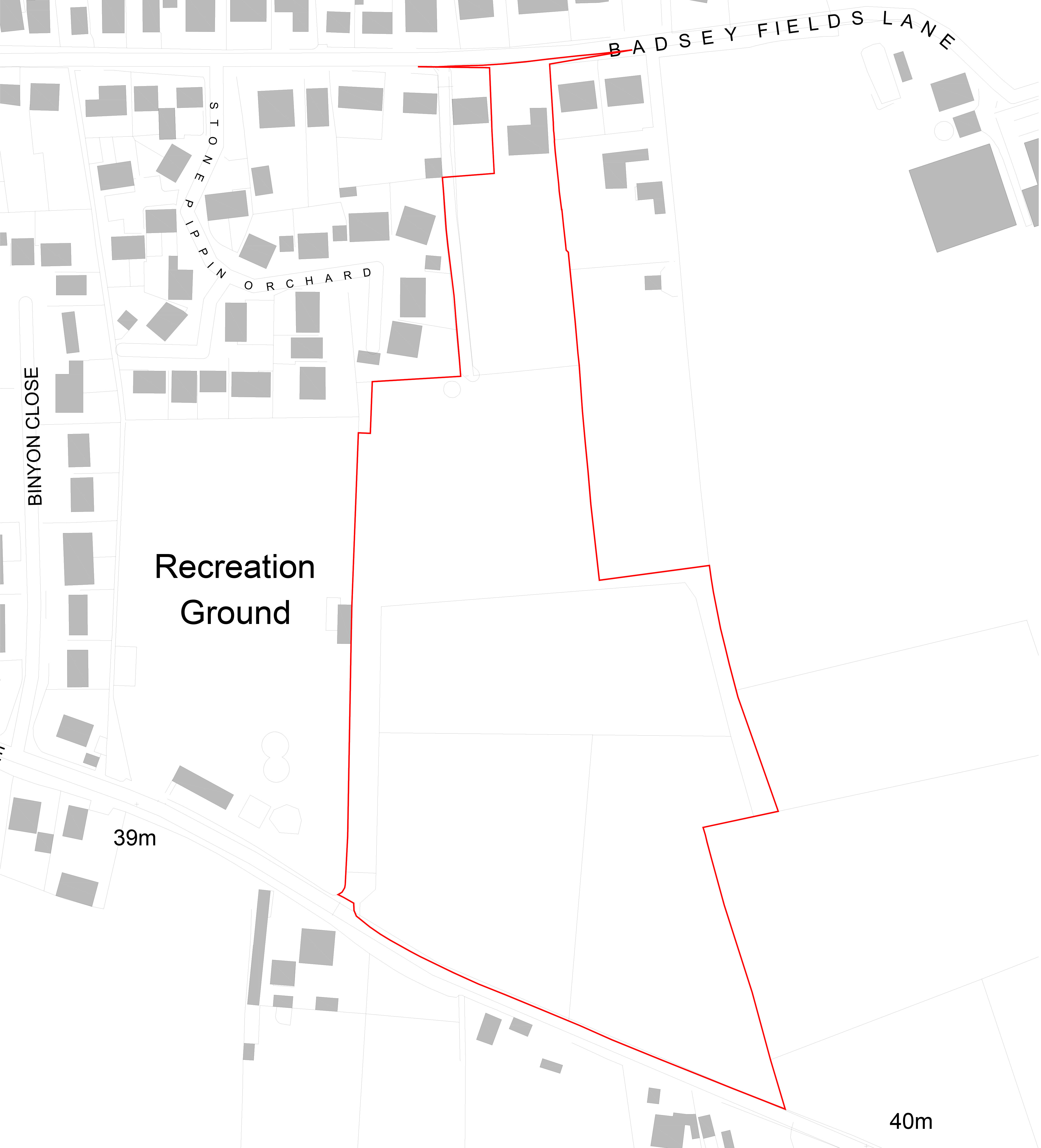
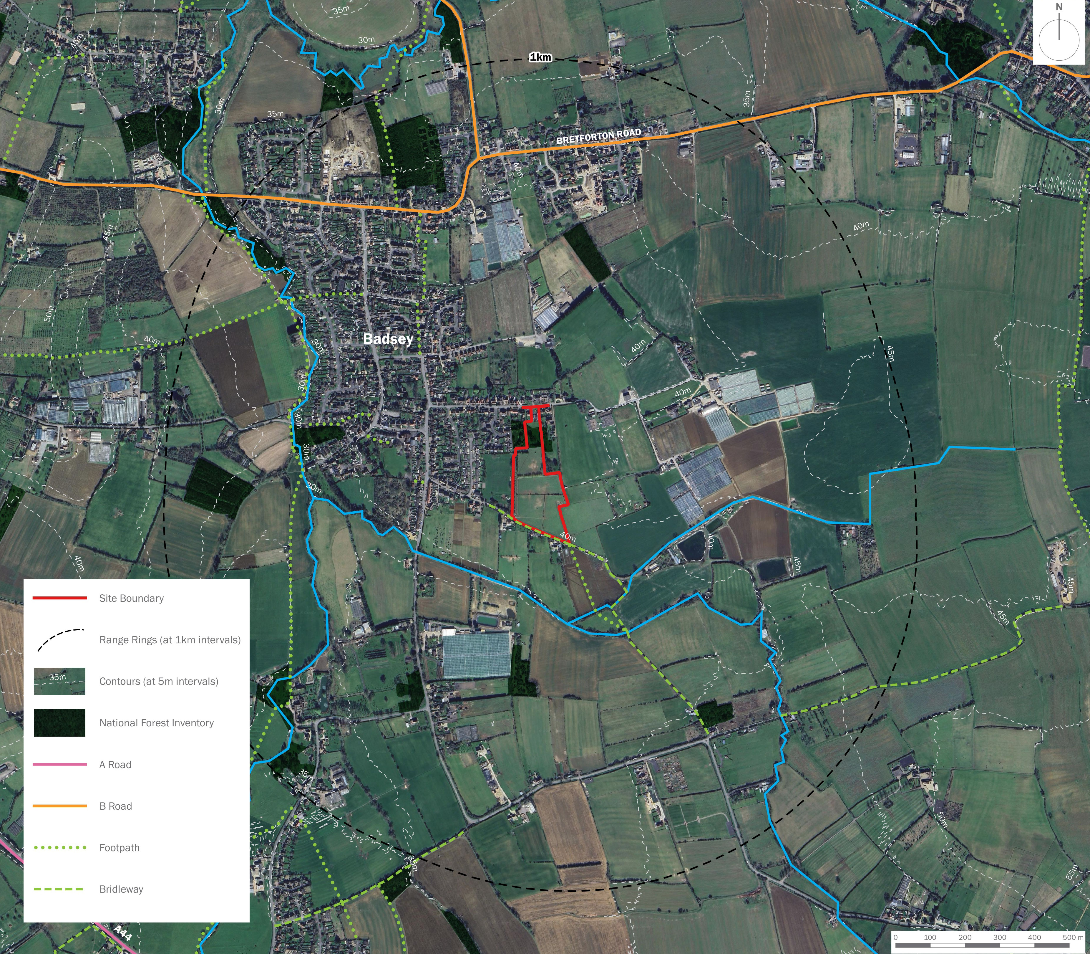
The site is located on the eastern edge of the village and parish of Badsey in Worcestershire, situated approximately 3km east of Evesham.
The site currently comprises 3.49 hectares of predominantly pasture with some land within the curtilage of an existing dwelling house on Badsey Fields Lane.
It is bounded to the east by further land associated with dwelling houses and undeveloped greenfield land. To the west the site abuts existing dwellings at Stone Pippin Orchard and the Recreation Ground.

Planning Context
What is an outline planning application?
An outline planning application seeks to agree the principle of development on a site including the land use (in this case, residential) as well as identifying a masterplan for the proposed developable area. That’s why you may not see the level of detail in the plans you would expect. If an outline planning application is granted planning permission, this must be followed by a ‘reserved matters’ submission showing more detail, which will be determined separately by the Council.
As part of this outline planning application for up to 75 new homes, Rainier is seeking approval for the principle of development and access only. Permission for all other matters including layout, scale and appearance of the new homes will be agreed with the Council through a further reserved matters application, which will also be subject to further consultation with all stakeholders.
Why are more homes needed in Badsey?
Wychavon District Council is required to bring forward sites for housing to meet its needs, which is calculated based on housing demand and population statistics by the Ministry for Housing, Communities and Local Government. Wychavon District Council must deliver at least 976 new homes every year.
Badsey is a well-connected and sustainable location for new housing. The village already benefits from a range of local services and amenities, including a shop, pubs, and primary school, reducing the need for long journeys by car. It is served by a frequent bus route providing easy access to Evesham and Honeybourne, where a wider range of facilities is available.
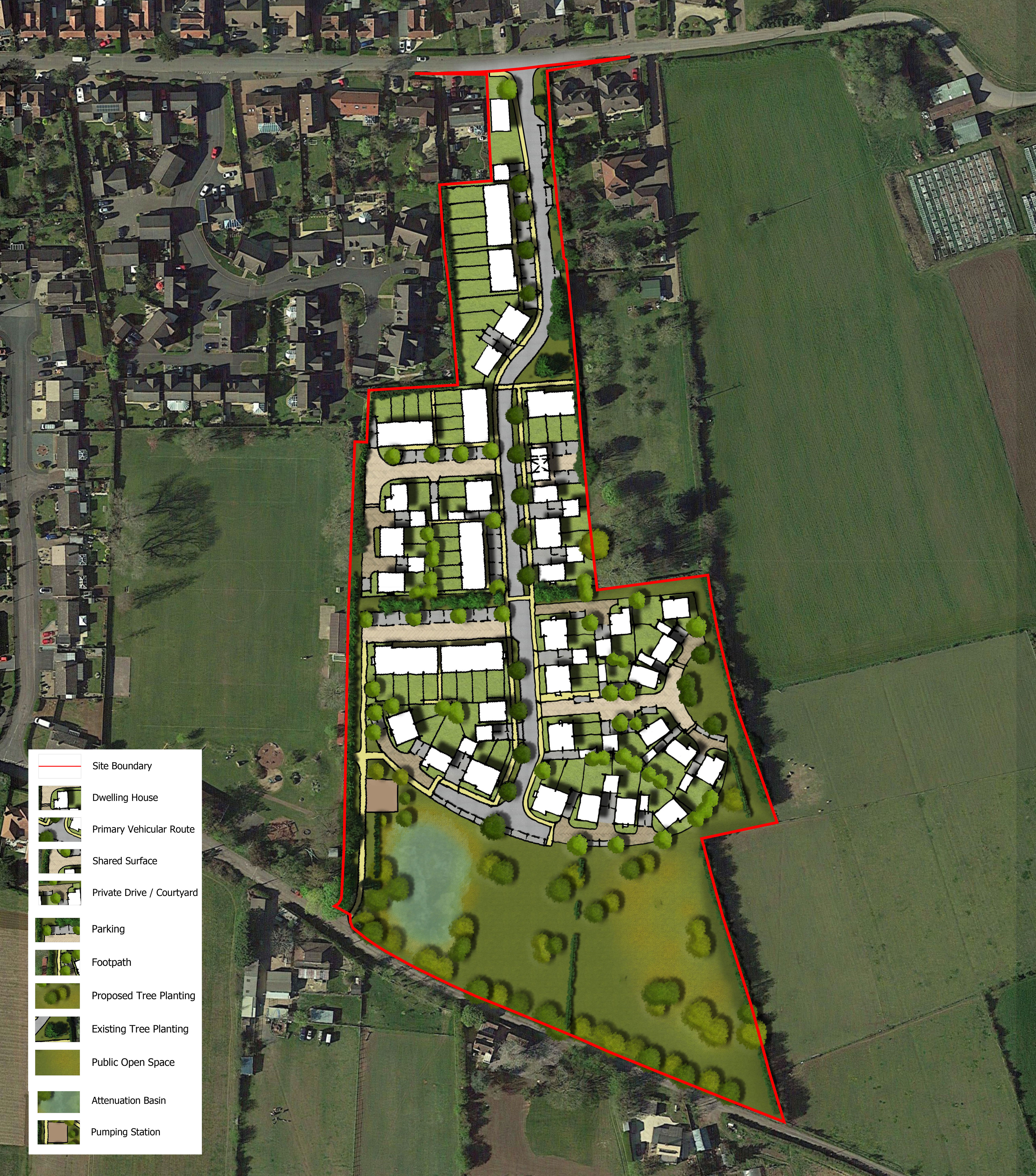
Emerging Proposals
Our emerging masterplan shows how we think the new homes, access routes and public open space could be delivered within the site.
The development would provide:
- Up to 75 new homes, offering a range of dwelling types, sizes and tenures to help create an inclusive new community. 40% of the new homes would be designated as affordable housing which means that they would be available at a discount to normal market rates via a registered housing provider for social rent, affordable rent, or intermediate housing, such as shared ownership or rent to buy.
- A responsive design that reflects local distinctiveness and sits comfortably within the current vernacular and landscape context.
- Homes built to Future Homes Standards.
- A sustainable development, responding to the core principles of the National Planning Policy Framework(NPPF).
- A site that is well connected and designed to encourage and support walking and cycling, with strong links to the Recreation Ground(subject to consultation), local services and facilities.
- A new landscape edge to the eastern boundary will help to create a transition from development to the surrounding countryside.
- Where possible, existing landscape features will be retained and enhanced within public open space to help development blend positively into the village and character of the site.
Landscape and Ecology
Landscape
A landscape and visual appraisal has been carried out to assess the site’s landscape character and visual amenity. The visual envelope of the site is limited by the low lying landform and layers of vegetation in the surrounding landscape.
The site is influenced by its immediate context, the residential development to the north and north-west, and lane to the south and the agricultural land to the east. From within the site, views are largely limited to the near distance, that is, views adjacent to the site itself. Medium to longer distance views are less prominent due to the immediate site context, although views from the Cotswold National Landscape have been included in the appraisal.
A landscape strategy is being developed to strengthen the green infrastructure network on and within the site. A design principle will also be to maintain a sense of openness in the south of the site which respects the character of the adjacent bridleway. This will involve setting development back from this edge and designing a suitable area of public open space in the south of the site. Some trees in the centre of the site will need to be removed to facilitate the proposals however the site’s edges and boundary vegetation will be bolstered, particularly where only fences demarcate edges. Vegetation will be managed to maintain a level of privacy and separation from neighbouring land. Proposed new planting will include native trees and hedgerows, amenity and wildflower meadow grassland.
The landscape strategy will include formal and informal landscaped areas for recreational and biodiversity benefits, attenuations features, ecological ponds and a pedestrian and cycle route around the site.
Ecology
No part of the site is covered by any statutory or non-statutory designations and there are no ecological corridors that connect the site to designations in the local area.
The site is predominantly neutral grassland. Other habitats include hedgerows, mown grass and a residential garden with tree planting in the north of the site.
The landscape proposals for the site will provide good quality habitat of higher ecological value including areas of wildflower grassland and understorey planting.
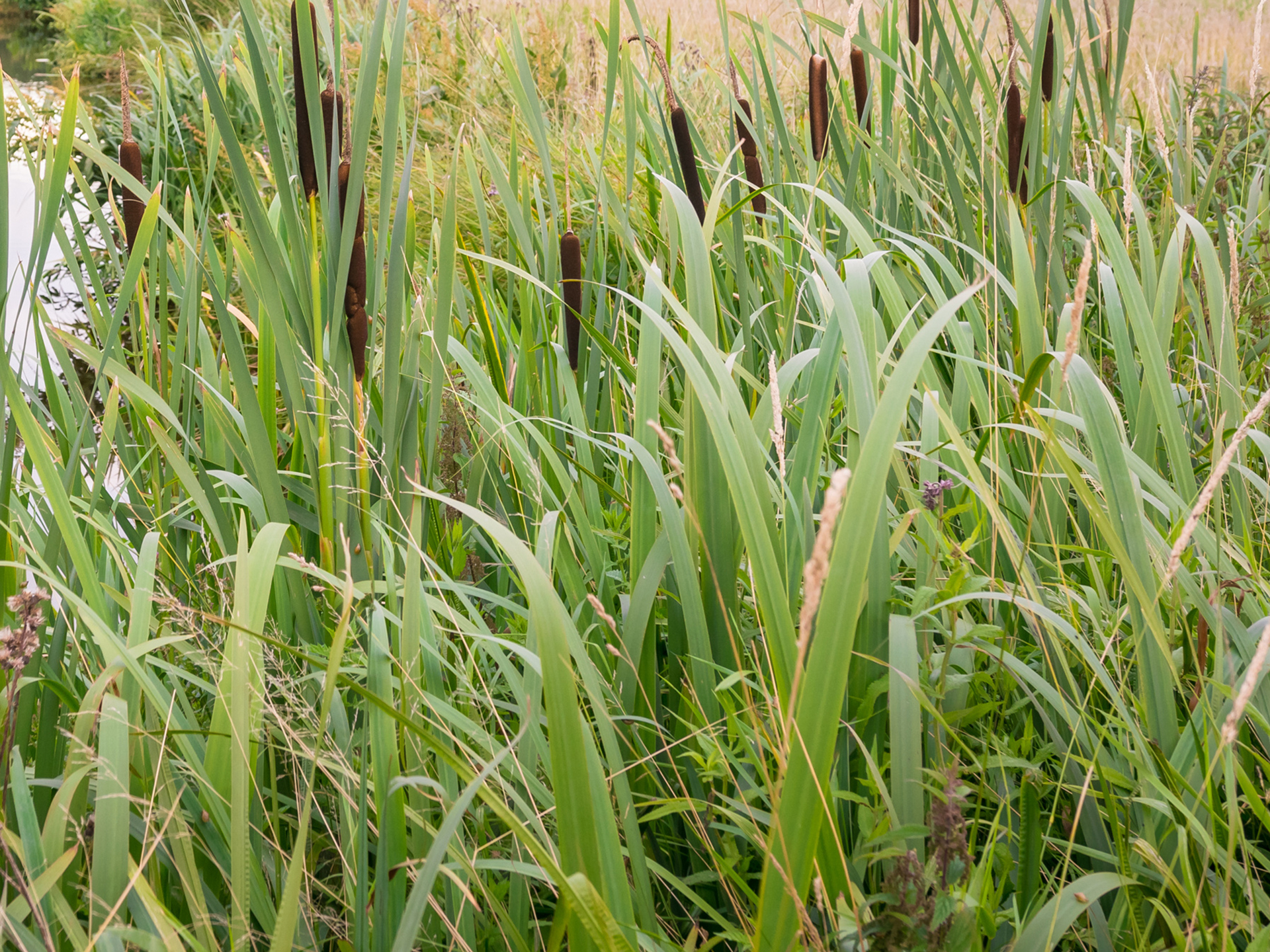
The attenuation ponds are to be designed to be wildlife friendly, and by providing fruiting trees and shrubs the site will be enhanced for bird foraging.
Bird and bat boxes to provide suitable foraging and commuting corridors. Bee bricks and hibernacula will also be incorporated for biodiversity enhancement.
Access & Transport
Vehicular access to the proposed development will be provided via a new priority ‘give way’ junction on Badsey Fields Lane. The access road will be 5.5 metres wide, with 6-metre radii at the entrance to accommodate turning vehicles. The existing width of Badsey Fields Lane, 4.5m, will be retained.
The site is well-placed to support sustainable travel, with a range of services and facilities in close proximity. Several local amenities are within 800 metres of the proposed site, and all are within a 2-kilometre walking or cycling distance. This includes primary schools, bus stops, local shops, pubs, and places of worship. The convenient location of these destinations encourages future residents to make day-to-day journeys using sustainable transport options.
The 247 and 553 bus services currently run along Willersey Road and Chapel Street, approximately 350 metres (a 4 minute walk) from the site, allowing access to local services in Evesham and Redditch.
Pedestrian access will be prioritised through the provision of a 2-metre-wide footway which flanks the western side of the site access road. This path will connect to the existing pedestrian infrastructure on the northern side of Badsey Fields Lane via a dropped kerb crossing located at the new vehicle access. An additional pedestrian and cycle link to Sands Lane, and in turn Bridleway 513(B) will be provided at the southwestern corner of the Site.
-Site-Access-Drawing.jpg)
Drainage
A full drainage strategy has been prepared as part of this planning application, which details how the proposals will manage drainage across the site and comply with local and national guidelines.
Surface water will be conveyed to an infiltration basin located in the south-west corner of the site. The basin has been designed to reflect the measured infiltration rates and to ensure compliance with design standards in relation to groundwater depth.
A second basin is proposed in the south-east corner of the site to manage surface water from the eastern boundary. This feature will intercept and convey overland flows to the basin, where water will be discharged to the ground through infiltration. The masterplan will also make provision for an interceptor or cut-off trench along the eastern boundary. Foul drainage will be managed via an onsite pump station, with flows directed to the existing Severn Trent Water network, subject to ongoing discussions regarding the point of connection.
A management company would be responsible for maintenance of the infiltration basins and associated public open space.
Sustainability
The new homes will be designed to achieve the Future Homes Standard 2025, which will ensure they are all-electric, with high levels of fabric efficiency and powered by renewables. This will reduce carbon and energy bills for the residents, whilst also having a positive environmental impact.
The scheme will meet the requirements of the Future Homes Standard 2025 that are summarised below:
- Energy efficiency and heat loss - Homes built to FHS must meet new requirements around energy efficiency. There will be stricter limits on heat loss with a focus on airtightness and improved insulation standards.
- Low-carbon heating systems - Oil and gas fired heating appliances will be phased out in favour of electric heating solutions (air and ground source heat pumps), solar thermal, battery storage or district heating solutions, which can help manage demands on the power grid.
- Zero Carbon Ready - Homes should be built to enable the adaptation to zero operating carbon emissions without having to rely on future ‘bolt on’ products once the UK’s grid is decarbonised.
- Carbon-efficient materials - Embodied carbon will need to be considered as part of design proposals.
- Smart technologies - FHS will also encourages the integration of smart home technologies. These systems could help homeowners manage smart thermostats, electricity generation from PV panels and water heating.

Have Your Say
We would appreciate your feedback before we finalise our proposals and submit an outline application to Wychavon District Council.
Before submitting your feedback, please note that we have prepared a series of frequently asked questions, which you can view here.
The information you provide will be used only for the purposes of keeping you informed about this project and for understanding public opinion on the project. It will be stored securely until completion of the project, after which this information will be deleted. Your information will only be shared with third parties for the express purpose of keeping you informed of the proposals, and with Rainier Developments and Strategic Land and/or the relevant local authority where there is a legal obligation to do so. It will not be forwarded on to any other third parties. You can contact us at any time to request the deletion of your information. Please contact us at contact@rainier-badsey.co.uk .
Q&A
We understand that proposals like this raise important questions from the community. That's why we've included answers to some of the most common queries about the planning application.
Any planning permission is likely to be required to make financial contributions to local schools, healthcare facilities, transport infrastructure and utilities, if requested by the relevant bodies. The level of these contributions will be determined as part of the planning process and in consultation with service providers.
40% of the housing delivered as part of the proposals will be affordable housing, which is compliant with Wychavon District Council’s local policies. The mix and sizes of the homes made available as affordable housing will be determined during the planning process.
Affordable homes are homes made available via a registered housing provider for social rent, affordable rent, or intermediate housing, such as shared ownership or rent to buy, helping people on to the housing ladder who are unable to afford to rent or purchase a home through other means.
Vehicular access to the proposed development will be provided via a new priority ‘give way’ junction on Badsey Fields Lane. The access will be constructed after the demolition of the dwelling at 32 Badsey Fields Lane.
A sustainable drainage system (SuDS) will manage surface water onsite to prevent increased flood risk to the site and surrounding areas.
The SuDS will be designed to accommodate a 1 in 100 year flood event, with an additional allowance for climate change. They will attenuate, treat and then release water into the existing network at a rate which is comparable to that which it is currently.
A Construction Management Plan will be agreed with Wychavon District Council to minimise disruption, manage vehicle movements, and control noise and dust. We would anticipate this forming a condition should planning permission be granted and details would be submitted to and agreed with the Council prior to work commencing on site. If permitted, working hours on the site will be controlled via planning conditions to ensure disruption is kept to a minimum. A safe and direct route for construction traffic movements will be agreed with the highways and planning departments.
Contact Us
If you have any comments or questions or would like a hard copy of any of our consultation materials, please contact us.
Send us a message and we will get back to you as soon as we can: